Click on the thumbnail for a larger image
Cass Lake was the site of the first North American Championship in 1953 (called the "Annual Regatta" in the day). The North American Championship was also sailed at Cass Lake the following two years, and again in 1965. Although considered to be too small for a major regatta these days, it is still one of the favorite sites of the Detroit fleet. It is possible to set a 3/4 mile course in most wind directions, and slightly longer than a mile if the wind is from the Southwest or Northeast. Plan on being schooled in sailing a short shifty technical course.
Directions:
I-75 Traveling North or South:
- Take the Square Lake Rd exit heading West for ??? miles
- Turn right onto Telegraph Rd (North)
- Exit right to Orchard Lake Rd
- Turn left onto Orchard Lake Rd (South)
- Turn right onto Cass Lake Rd
- Turn left onto Cass Elizabeth Rd
- Turn left onto Parkway (there is a small wood sign on the right side of Cass Elizabeth marked (Doge Bros State PArk #4)
- Follow Parkway to the end and enter the park
I-59 Traveling East:
- Turn right (South) on Cass Lake Rd
- Turn right (West) on Cass Elizabeth Rd
- Turn left onto Parkway (there is a small wood sign on the right side of Cass Elizabeth marked (Doge Bros State PArk #4)
- Follow Parkway to the end and enter the park
I-59 Traveling West:
- Turn left (West) on Elizabeth Lake Rd
- Turn left (South) on Cass Lake Rd
- Turn right (West) on Cass Elizabeth Rd
- Turn left onto Parkway (there is a small wood sign on the right side of Cass Elizabeth marked (Doge Bros State PArk #4)
- Follow Parkway to the end and enter the park
From all directions:
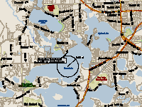
- Follow the signs to the beach parking lot
- Don't launch at the beach. Set up and launch at the far end of the parking lot, over the small (1 ft) seawall.
Sailing Notes:
When stepping off the seawall, the water depth is less than 1 ft and the ice here tends to melt before the ice on the main part of the lake. This shallow area extends for around 200 feet out towards the main part of the lake. Use caution when sailing into and out of the launch area, especially at the end of a warm day.
Don't sail around the point to the right of the launch (up into the bay). A river flows into the lake through this bay and the ice is thinner than out on the lake. Likewise, sailing along the shoreline to the left of the launch will lead to a small cut opening into a bay -- don't sail through this opening, it is almost always open or covered by very thin ice. As on all sites, stay away from the shoreline in general, and stay out of the small bays.
There is frequently a pressure ridge (or two) running across the lake, with Dodge Park in between the ridges. One of these ridges will originate at the point of land (Ward's Point) across the lake to the left, and runs to the left side of the launch site. The other ridge originates off the beach to the right of the launch, and runs across the lake to the right side edge of the far bay (Dow Ridge). Be careful when sailing until the extent of any pressure ridges has been mapped out.
Updated October 6, 2003